Monday, 15 April 2019

New Zealand: Wellington, Marlborough and Punakaiki


From Ohakune we continued south to Palmerston North. Shirley, our lovely neighbour in Perth, is a Kiwi and her sister Robyn lives in their hometown. Thank you so much for having us Robyn and Tony! Was so lovely to meet you after hearing so many wonderful things from Shirley. Thank you for spoiling us with the delicious date and nut scones, it was such a treat. Hope to see you all again soon =)

From ‘Palmy’ we continued to Wellington, New Zealand’s capital city and second most populous urban area. Wellington reminded us so much of Cape Town and surrounds. A little bit hilly, a lovely botanical garden, a funky city centre, a maze of one way streets, many beautiful wind-swept bays for exploring right on the waters edge, white sand and rocky beaches, crazy traffic even on a Sunday, cricket fanatics, filming central, stunning viewpoints, a cable car, museums and the list of similarities goes on! We were a little optimistic on what we could fit in to one afternoon and felt largely thwarted by the traffic, due to a cricket game and the fantastic weather. We enjoyed a drive along some of the bays and a café-style late lunch overlooking the rocky shoreline, views of the city from Mount Victoria, a wander around the botanical gardens, the beautiful hot sunny day and a chilled night cap in a waterfront pub. We didn’t spend much time in any NZ city but Wellington was definitely a firm favourite. 


Views of Wellington City from Mount Victoria on a beautiful cloudless day


Wellington Botanical Gardens
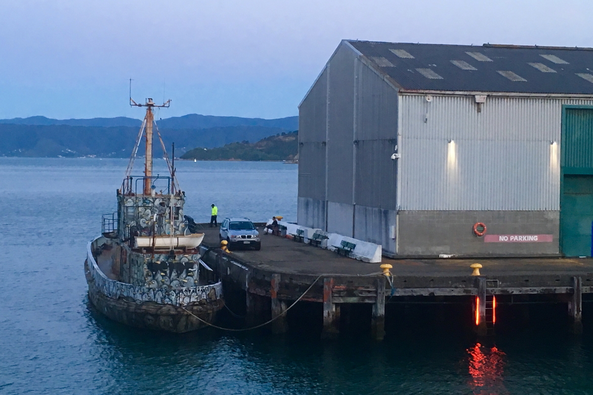

Harbour at dusk

The next morning we took the Interislander ferry from Wellington across the Cook Strait and through the Marlborough Sounds to Picton, our first destination on the South Island. It was a cloudy and cool start to the day but soon cleared into another hot day. The ferry takes about 3.5 hours; there are movies and a kids play area, and many people relaxed and took a nap in the quieter seating areas. We were mostly on the top deck soaking in the views and fresh air. The ferry hugged the North Island coastline before heading into the strait so the open and exposed part of the crossing is very short making for a smooth journey. Coming into the Marlborough Sounds was so beautiful, it was really special to experience the sound from the water.


View of the harbour from the Wellington Interislander Ferry Terminal 


Setting out from Wellington on the ferry 


The Marlborough Sound

After collecting the car, we drove from Picton to Havelock along the Queen Charlotte Drive and stopped at many view points and walked down the hill and back to some secluded beaches. There is much to explore and discover in the Marlborough Sounds, it’s a holiday in itself! We had to be content with a few hours. From Havelock we made our way to Renwick in the stunning Wairau Valley wine region. Our accommodation was up on a hill with sweeping views of vineyards and the Wither Hills and we enjoyed a picnic dinner with a glass (or two…) of the local finest on a perfect evening while the sun set.


Views of vineyards and the Wither Hills from our accommodation in Renwick 

From Renwick we crossed from the East to the West coast of the South Island with a stop at the Nelson Lakes and the small town of Murchison along the way, it was a beautiful drive through vineyards and mountains. The first stop on the West Coast was Punakaiki and the Paparoa National Park. The day began hot and clear but cooled down and clouded over as we made our way toward Punakaiki. A little drizzle wasn’t going to stop us from an evening walk on the beach! Some cooler weather was very welcome after a blistering week.


Views of the Nelson Lakes National Park 


Stunning coastline around Punakaiki on a misty evening 


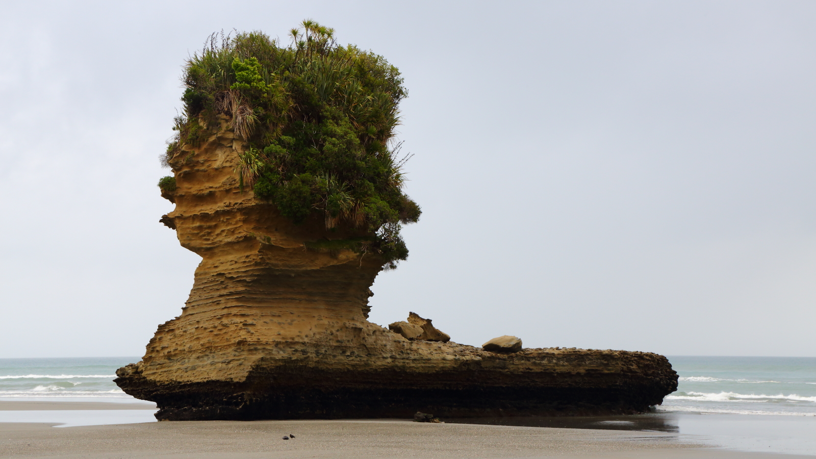
Interesting eroded rock formations on our beach walk 

The next day was a slower rest day after a few busy travel days in a row. The day began cloudy and cool but cleared and heated up by midday. Exploring started with the Porari River Track, a one hour walk along the Porari River into the Paparoa National Park. We enjoyed this quiet and peaceful track with many unique birds flitting about. One can return along the same route or along the southern section of the Inland Pack Track. We chose this option even though the end is quite far from the beginning. This suited us though since the walk back to our accommodation passed Dolomite Point with the Pancake Rocks and Blowholes. The Blowholes are best viewed at high tide so we timed our return walk with the tides and were there at the right time. The Pancake Rocks is a unique set of weathered limestone giving the impression of stacked pancakes. At high tide the sea is forced through holes at great force in the rocks hence the name blowholes. We discovered however, that there needs to be quite a big swell in addition to high tide for this to be efficient. Even if the blowholes are not working that day, it’s still worth a walk around this easy loop track right off the main road at any tide.


Part of the Porari River Track 


A delightful New Zealand Bush Robin


A Weka, a flightless bird species endemic to New Zealand


Pancake Rocks 

In the afternoon we enjoyed the short Truman Track through beautiful forest down to a fine gravel beach where cliffs, caverns and interesting rock formations await. And another misty evening walk on our own gravel beach. Many people only stop here for the Pancake Rocks or spend one night at the most. This stunning coastline is worth some attention and Dolomite Point isn't the only place you will see interesting rock formations.  There are a few nice tracks in the area and we are glad we had a travel ‘rest’ day to enjoy this area.

From Punakaiki we continued down the West Coast to Franz Josef and glacier country.

More on that next time!

Saturday, 30 March 2019

New Zealand: Tongariro National Park


From Lake Taupo we continued on to our next stop, the Tongariro National Park. The road there was quite an adventure in itself! Very windy, narrow and quite steep in sections with a few hairpin turns, but we made it. We chose Ohakune as a base to explore the park. Winter is the high season here, so the town was really quiet, many stores had shorter opening hours or were completely shut for the whole summer. Winter skiing seems to be the main attraction but Summer is beautiful too with many hikes and mountain bike trails to choose from.

We had three full days to explore the park. There are so many wonderful hikes to do. Judging by how quiet the different tracks, many people seem to focus on the Alpine Crossing but it was definitely worth spending some extra time and doing some of the other hikes. The first day in the area was forecast to be just as hot as the whole week had been and then cooling down with some rain expected on the third day. We chose to do a warm up hike on the first day to stretch our legs and get the lay of the land before tackling the Alpine Crossing on the second day. The third day would be a rest day.

We chose the 17 km Tama Lakes with a similar landscape to the crossing as a warm up hike. This track is an extension of the two hour Taranaki Falls hike and is also part of some multi-day hikes and is well-known for beautiful and uninterrupted views of Mt Ruapehu and Mt Ngauruhoe all the way to the lakes on a hot clear day such as it was. The route is mostly level on a well-formed and easy to navigate track but also open and exposed with low tussock grasses and alpine herbs as low scrubby vegetation. From the viewpoint of the lower lake it is a short but steep climb up a scree slope to the viewpoint of the second lake. Even on a calm day the wind was howling here on the Tama Saddle between Ruapehu and Ngauruhoe, a windproof jacket is a must. While we were at this viewpoint of the upper lake, we heard and a loud eruption coming from somewhere nearby which was a little unnerving. There were not many people around, but those that were didn’t seem too perturbed. We concluded that it must be a frequent occurrence but also didn’t stick around for much longer. We didn’t fancy being out on an exposed track if a bigger eruption followed soon after! We passed Taranaki Falls on the way back to the info centre and start of the hike. The vegetation changed much at this part of the hike to tall trees and lush forest around the stream. Also nearby is Tawhai Falls which was used as Gollum’s Pool in the Lord of the Rings movie trilogy. We enjoyed cooling our hot feet in the cold rushing water!


Mt Ngauruhoe on the Tama Lakes hike


Mt Ruapehu on the Tama Lakes hike


View of the lower Tama Lake and Mt Ruapehu


The lower Tama Lake


The Upper Tama Lake and Mt Ngauruhoe


Mt Ruapehu 


Taranaki Falls 


The stream flowing from Taranaki Falls 


Tawhai Falls
Gollum's Pool in The Lord of The Rings trilogy 


The next day was misty, cloudy and cool in the early morning, perfect for tackling the Tongariro Alpine Crossing. Billed as New Zealand’s best day hike, the crossing is a 19.4 km 6-8 hr hike from the Mangatepopo Road car park to the Ketetahi Road car park. Some logistics is required since the start of the hike is a 40 min drive from Ohakune, it’s a one-way point-to-point walking route and the parking limit is 4 hrs. There are many shuttle bus companies providing a pick-up and drop-off service; while we found these to be a bit pricey, there aren’t many alternative options and actually we were quite thankful to not have to drive the 40 km back after this epic but exhausting hike.

The track is best viewed in sections. From Mangatepopo (approx. 1100 m) to Soda Springs it is easy going on a well-formed and mostly flat track with boardwalks over wet areas and we enjoyed the opportunity to stretch and warm up. From Soda Springs it was a steep and tough climb up Devil’s Staircase over layers of ancient and recent lava flows to South Crater (approx. 1660 m), fortunately it is a proper stepped boardwalk which helped a lot. South Crater to Red Crater starts with a short flat section as a reward after Devil’s Staircase before the final steep scree ascent to Red Crater (highest point of the hike at approx. 1900 m). It was cloudy and cool all the way thus far and cooled down further with strong winds up to Red Crater. We missed the amazing views that were to be had up to Red Crater due to the cloud and billowing mist, Justin was a bit bleak but Bron was thankful that it was a cooler day for hiking in this exposed environment.


Start of the Tongariro Alpine Crossing 


Also first part of the walk before Devil's Staircase 


Red Crater is to the right of this pic, final ascent before the steep scree descent


From Red Crater it cleared completely to reveal amazing views of the Emerald Lakes and Blue Lake, a reward for the steep descent down a scree slope that was more sliding and surfing on sand than walking. It was a little challenging with so many hikers on the trail. Some people were walking in the opposite direction on a different multi-day hike, not sure how they made it up that hill with so many people coming down! From Emerald Lakes (approx. 1700 m) it was a short and easier climb to Blue Lake and North Crater (approx. 1710 m) followed by a small mostly flat stretch before starting gently down to Ketetahi Hut. From the hut it is a steady and hard descent to the end of the trail at Ketetahi Road car park (approx. 700 m). Bron was a bit over the descent with still 3 km to go! It was a hard finish.


Red Crater 


Looking back at the steep scree descent from Red Crater


One of the Emerald Lakes 


One of the Emerald Lakes looking forward to the rest of the hike


The same Emerald Lake looking back at the steep scree descent from Red Crater
This pic doesn't really do justice to how steep this slope is! 


Emerald Lakes with Red Crater in the background


Steam rising from the ground 


Before Blue Lake looking back at Emerald Lakes (unseen) and Red Crater almost enveloped in the clouds. 
In this picture you can appreciate how steep that descent is!


The vegetation also changes much through the walk, from alpine scenes with tussock grasses to almost none in the lava flows around Red Crater, to thick lush vegetation at the end. We completed the hike in about 6.5 hrs without rushing and including lots of time for taking photos, catching our breath, having a snack, and enjoying the views. If you are planning to tackle the crossing, do some homework beforehand and come prepared with water, food, a basic first aid kit, appropriate footwear, and suitable clothing bearing in mind conditions can change rapidly. This was a challenging and demanding hike but definitely worth it and the label of NZ’s best day hike!


Blue Lake, halfway point of the hike


Looking back at Red Crater from Blue Lake 


Start of the descent down to Ketetahi Hut and Road


Bron on the descent to Ketetahi Road

The challenge and awesomeness of the Tongariro Alpine Crossing is difficult to convey in a few words and pictures! Enjoy this GoPro video for a more comprehensive overview of our day out! (If you experience difficulties with the link, copy and paste this URL into your web browser: https://gopro.com/v/8vGl6r68My4Vn)

That night was forecast to rain and we enjoyed sleeping in late and a very slow start with a delicious brunch. Our third day in this area was much slower but we still wanted to stretch after the long hike. We kept it local and took a drive to the start of the Mt Ruapehu ski fields and also stopped at the Mangawhero Falls viewpoint. We enjoyed the nice flat and well‑formed 4 km return Waitonga Falls walk through some forest and also open plains. The last walk for the day and this area was the 3 km Mangawhero Forest Loop.


Misty day for a walk to Waitonga Falls 


Waitonga Falls and stream


Spider web at the falls 


On the Waitonga Falls track 


Mangawhero Forest 


View of Mt Ruapehu at sunset from our accommodation.


Thank you Tongariro National Park! 
Next time: Wellington and Marlborough.