Can you see the swans fly?
Now half asleep in bed I lie,
Awake with half an eye.
Heyho and welladay,
Over hills and far away,
That's where the little children stray
To find lambs at play.
- An Icelandic lullaby on the IcelandAir pillow.
A land of weather extremes, a land of poets, a land where sheep and horses freely roam the fields, a land that is home to more birds than people, a land where the language hasn't changed in 1000 years. This is Iceland. The weather may chilly and unpredictable, but the people are warm and friendly.


We were greeted with a persistent chilly rain upon arrival in Reykjavik that lasted the rest of the day. After collecting our rental car and checking into our accommodation, it was time to check out the city of Reykjavik! We wandered the streets in search of traditional Icelandic knitwear, visited the church, and made a great choice in restaurant for dinner.
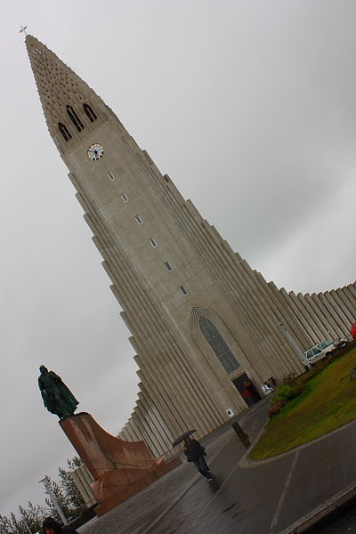
Hellgrimskirkja

The view of the city centre from the top of the church

The Sun Voyager (Solfar) sculpture
The first day of exploring dawned bright and clear but with a wind more
vicious than anything I have ever seen in Cape Town adding serious wind chill
factor to the mid-day high of 10ºC. We decided to explore Iceland's Golden
Circle: Þingvellir National Park, Geysir, Gulfoss waterfall and Kerid Crater. (Þ
is pronounced as a ‘th’ sound)
First stop was Þingvillar National Park. Þingvillar is situated in a
rift valley marking the crest of the mid-atlantic ridge or more simply put, where
the American and European continental plates meet. The plates are said to be
moving apart 2 cm a year; the ridge of the European plate can clearly be seen
rising above the valley offering some protection from the wind. Þingvillar is
also situated on the Northern shore of the largest natural lake of Iceland, Þingvallavatn.
Þingvillar was the seat of the first Icelandic Government known as the 'AlÞing'.
The AlÞing was held for two weeks over the summer every year since 930 until
1800. This was where the rules and laws of the land where decided upon and
disputes settled. The river Oxara, with the clearest water, runs through the
lush green valley. It was lovely wandering around this area trying to imagine
what attending an AlÞing must have been like in these open fields subject to
the elements. Icelanders like to remember and celebrate their rich Viking heritage
and still use this site for important events, concerts and celebrations.

The edge of the continental plate

Bron and Justin with Oxara river in the background

A small church down in the valley

More views of the valley

Next stop was the hot vents of Geysir! Here steam rises from cracks in
the ground and water bubbles in open crater-like vents. Geysir is no longer
active but there are some other interesting vents nearby. The most impressive
is Krokkur, erupting a jet of piping hot water and steam up to 30 M in the air
every few minutes. Litli Geysir only bubbles away and Blesi is a set of twin
pools; one crystal clear, the other blue and opaque. Water temperatures in this
area are 120-150ºC while underground water temperatures can reach 300ºC or
more. The Geysir area is the most well-known of the hot vents, but there are
vents all along where the two plates meet. It is quite interesting driving
along and seeing steam rising out of the ground!

Standing around, waiting for a geysir to erupt

And there it goes!

The eruption

And the empty crater after the show

The two pools called Blesi (above and below)


Litli Geysir

The view up the hillside towards the various geysirs
From Geysir we went to Gullfoss or the Golden Falls, a double set of
impressive and powerful waterfalls. Iceland's first environmental activist was
Sigriour Tomasdottir, a lady who in the 1800s campaigned against the
destruction of these beautiful falls. The noise and spray is impressive and
Justin and Bronwen got quite wet getting up close! The restaurant at Gullfoss
serves a mean Icelandic lamb soup which we enjoyed while gazing upon one of
Iceland's glaciers, Langjokull. Last stop for the day was Kerid Crater. Formed
from a blown out volcano, the red crater created now contains water.


Enjoying some lamb stew (and then again thanks to the free refills!)
Langjokull (a long panoramic so best viewed if you click on it)

Getting up close and personal with some Icelandic horses on the way back to the hotel

The next day it rained the whole day! But we made use of the day with a
road trip around the Southern part of the Island down to Grindavik and back up
to Reykjavik past the Blue Lagoon. Grindavik is a small coastal fishing town
where we visited the Salt Fish museum. Fishing, salting and exporting cod was
the main livelihood of Iceland for many years. So much so that a filleted cod
appeared on the national coat of arms. This museum covers the history of the
cod industry. But before we headed on the road trip, we visited a geothermal
energy plant.
All of Iceland's electricity is 100% green, produced either by
geothermal- or hydro-power. Geothermal energy makes up 30-40% of the total
electricity produced on the island. Hot water (300ºC) is pumped from a depth of
3 km underground. The steam is separated from the water and is pumped under
pressure to where it drives turbines for the generation of electricity. Left
over steam and the separated hot water is used to heat fresh water which is
then pumped to the end user. This water is 83ºC and only loses 2ºC by the time
it reaches Reykjavik 20 km away. Any remaining water is pumped back into the
ground to be naturally heated again. The whole plant smells like Sulphur
because of the thermal water. When we used hot water at our accommodation we
noticed a sulphur smell and now we knew why! In theory, Reykjavik should never
run out of hot water. We felt less bad about using hot water after visiting the
geothermal plant.

The Salt Fish Museum

Some of the countryside that we drove through

Our third and last full day in
Iceland was another clear beautiful day, and less windy. We headed to the area
South of Reykjavik to track down more waterfalls and look out for Puffins and
other birds at the impressive sheer cliffs at Dyrholaey.
First stop was Seljalandfoss,
a narrow but powerful waterfall that drops into a shallow pool below. There are
stairs to climb to walk to the back of the falls. It's pretty dry behind the
falls and lovely for a different view of the falls and surrounding area, but
bring a raincoat, you will get pretty wet on the way to the back! On the path
nearby there are some lovely smaller falls to be seen, less impressive, but
still beautiful.
At 09:30 am, there were only a
handful of people visiting this impressive natural feature. All the natural
attractions of Iceland are relatively untouched. At most of the big attractions
there is a visitor centre with information, souvenirs for sale and usually a
cafe of sorts. But apart from that there are no fences, entry fees, big signage
or anything else you would expect from a big tourist attraction. It is really
lovely to enjoy the land in it's natural wild state.


Seljalandfoss


The view from behind Seljalandfoss
After Seljandafoss, we headed
to Skogarfoss, a powerful curtain waterfall with a 62 m drop where rainbows
play in the spray surrounding the pool. We climbed the steep stairs for a view
of the waterfall from the top and the river beyond.
On the way to the next stop,
we passed the volcano that erupted in 2010 causing air traffic in Europe to
come to a grinding halt due to the persisting ash cloud, the easy to pronounce
Eyjafjallajokull. We stopped for a look and to give Dad Cross a chance to give
the volcano a piece of his mind after their last planned trip to America was
cancelled due to the ash cloud.


Next stop was the impressive sheer cliffs of Dyrholaey. This is the Southernmost tip of Iceland and a well known sea-bird reserve. Every available crevice is occupied with nesting birds during the Summer months but the reserve is closed during this time. We were grateful for our 4x4 rental car to get to the top of the cliffs for the best views of Iceland's version of Coffee Bays hole-in-the-wall and Reynisdrangar or the troll rocks; three tall offshore spires said to be petrified trolls caught by the sun as they were trying to drag a boat ashore. Although this area is rich with birdlife, we only saw a few gulls, or they might have been arctic terns, circling around the cliffs. We were really hoping to see some puffins but alas, there were none to be seen. This area is so beautiful and dramatic with the sheer cliffs, howling wind, surrounding black sand beaches and the glacier in the distance. It feels so desolate and wild, it's so great.


Eyjafjallajokull

Icelandic sheep

Skogarfoss


Next stop was the impressive sheer cliffs of Dyrholaey. This is the Southernmost tip of Iceland and a well known sea-bird reserve. Every available crevice is occupied with nesting birds during the Summer months but the reserve is closed during this time. We were grateful for our 4x4 rental car to get to the top of the cliffs for the best views of Iceland's version of Coffee Bays hole-in-the-wall and Reynisdrangar or the troll rocks; three tall offshore spires said to be petrified trolls caught by the sun as they were trying to drag a boat ashore. Although this area is rich with birdlife, we only saw a few gulls, or they might have been arctic terns, circling around the cliffs. We were really hoping to see some puffins but alas, there were none to be seen. This area is so beautiful and dramatic with the sheer cliffs, howling wind, surrounding black sand beaches and the glacier in the distance. It feels so desolate and wild, it's so great.

A view of the troll rocks (Reynisdrangar)

A view of the black beach from the top of the cliffs

The lighthouse on top of the cliffs

Another view from the top of the cliffs with a glacier in the background
The glacier we saw in the
distance from Dyrholaey turned out to be not too far away. We handled the
gravel track to get closer with ease in our rented 4x4 and were soon walking
towards the glacier of Solheimajokull. Solheimajokull is a small glacier
stretching like a finger away from the bigger glacier of Myrdalsjokull. After a
quick snack break, we walked down the path toward the glacier. The edge of the
glacier was covered in black grit and not the pristine white we expected, but
where the ice had melted to create a crevice, intense blue ice could be seen.
We didn't walk very far on the ice as it was quite slippery but it was not as
cold as we expected it to be. Even though Solheimajokull is a small glacier, the
thickness and quantity of ice is impressive.


A self taken photo with the glacier behind us

Solheimajokull

We really wanted to go to the Þorsmork
National Park but a high wheel clearance 4x4 is needed to navigate the roads.
Solheimajokull became our last stop in this jam-packed exploring day. We beaded
back to Reykjavik to get ready to fly the next day and for a last yummy
Icelandic lamb dinner.
After checking out on
Friday morning we headed to the Blue Lagoon, a geothermal spa. The pools
are shallow and fiberglass lined and naturally heated mineral water flows in at
several points at a comfortable 38ºC. From above the water appears blue but at
surface level the water is white and turbid. We had a nice morning floating in
the pools smearing silica mud on our skin. The Blue Lagoon is definitely a
tourist rip-off and I don't think we would go back, but it was interesting to
check it out once.


Our last stop in Iceland was
the airport to drop off our rental car and catch our flight onto Boston. Some
other impressions of Iceland: The land is quite flat everywhere with no tall
trees or shrubs probably owing to the howling wind. All the people we came into
contact with spoke good English. The exchange rate is about 150 Krone to 1 Euro
and you pay 100s and 1000s of Krone's for items. Most Icelandic words and names
are very long and difficult for English speakers to pronounce. Although parts
of Iceland can be quite touristy, it never feels crowded and the land is still
pretty untouched. The people are very friendly and welcoming and are proud of
their country. We really enjoyed our time in Iceland and would recommend it to
anyone looking for a different adventure.
More about our interesting
landing at Boston Logan airport and our time in Boston next time!
Hope you are well!
x
... WOW! Breathtaking scenery!! Sjoe Justin, your photos are something else!! ...Time to start selling prints my dear! Love the hats, you all looked cosy!! ... Sounds like an intriguing place... Hhhhmmm... fancy a sleepover with Josh so Mom + Dad can check it out?! (hee hee).. xoxo
ReplyDelete